Harvesting Data From The Air
Capturing data with a Raspberry Pi & RTL-SDR

Are you ready to take your data capturing skills to the next level? With Software Defined Radio (SDR), you can capture and analyze data from the air like never before! Imagine being able to pick up signals from satellites, aircrafts, ships and even electronic equipment. SDR technology has made this possible by enabling you to manipulate and control radio frequencies using software. This opens up a whole new world of possibilities, allowing you to uncover hidden data that was once out of reach.
What is Software Defined Radio
Software Defined Radio (SDR) is a technology that allows radio frequency signals to be digitally processed using software rather than traditional hardware components such as filters, mixers, and amplifiers. This technology enables the manipulation and control of radio frequencies through software, making it possible to receive and transmit various types of signals such as voice, data, and video. SDR technology has revolutionized the way radio signals are processed and analyzed, providing greater flexibility, efficiency, and cost-effectiveness compared to traditional hardware-based systems. SDR is widely used in various applications including military communications, wireless networks, and spectrum monitoring.
The Raspberry Pi
Raspberry Pi is a series of single-board computers designed and developed by the Raspberry Pi Foundation in the United Kingdom. It is a low-cost, credit-card sized computer that is designed for educational and hobbyist purposes. The Raspberry Pi is equipped with a range of hardware components such as a central processing unit (CPU), memory, and input/output (I/O) interfaces, making it capable of running a variety of software and performing a range of tasks. It can be used for a wide range of projects, from simple electronics projects and media centers to full-fledged servers and gaming consoles. The Raspberry Pi is popular among hobbyists and students due to its affordability, versatility, and ease of use.

A Powerful Duo: Raspberry Pi and SDR
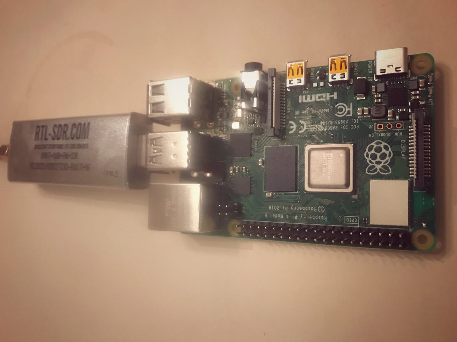
The Raspberry Pi and Software-Defined Radio (SDR) are an incredible duo when it comes to capturing and analyzing data from the radio waves that surround us. This powerful combination is like having a superpowered antenna, capable of uncovering a vast world of information hidden in the airwaves. Whether you're a hobbyist or a DIY enthusiast, the Raspberry Pi and SDR provide a low-cost, accessible, and endlessly customizable way to tap into the endless stream of data that is all around us. So, get ready to explore a whole new world of data with this dynamic duo!
Listening to ships with your Raspberry Pi:
To help prevent sea collisions, ships and passenger boats must broadcast an identification signal that includes position, course, speed, destination, and vessel dimensions. The system is called "Automatic Identification System" or AIS.
Marine traffic monitoring using a Raspberry Pi and Software Defined Radio (SDR) is a popular hobby among radio enthusiasts and marine enthusiasts alike. With the help of SDR technology, it is possible to listen to marine radio communications and track the location and movements of boats and ships. By connecting an SDR device to a Raspberry Pi, users can decode digital signals and display the information on their computer or mobile device. This provides a real-time view of the marine traffic in a given area, offering insight into the movement of vessels and their communication. The combination of a Raspberry Pi and SDR allows for a low-cost and accessible solution for monitoring marine traffic.
Here is an interesting article for getting started listening into AIS signals with a Raspberry Pi and SDR: AIS receiver on a Raspberry Pi with RTL-SDR (ronan.bzh)
<blockquote class="twitter-tweet"><p lang="en" dir="ltr">tuned in my <a href="

22, 2022</a></blockquote> <script async src="https://platform.twitter.com/widgets.js" charset="utf-8"></script>
Tracking Aircraft using a Raspberry Pi and SDR
To give air traffic controllers location and altitude information, aircraft use something called an ADS-B (Automatic Dependent Surveillance Broadcast) Mode-S transponder.
A Raspberry Pi + SDR can be used to listen to these ADS-B signals and decoded using Dump 1090, a Mode S decoder specifically designed for RTLSDR devices.
Here is the code needed for setting up the raspberry pi: GitHub - MalcolmRobb/dump1090: Dump1090 is a simple Mode S decoder for RTLSDR devices
<blockquote class="twitter-tweet"><p lang="en" dir="ltr">tracking flights overhead using a combination of <a href="

29, 2023</a></blockquote> <script async src="https://platform.twitter.com/widgets.js" charset="utf-8"></script>
Receiving Live Images from NOAA Weather Satellites
One of the most fascinating and accessible projects for amateur radio and SDR (Software Defined Radio) enthusiasts is receiving real-time weather images directly from NOAA’s polar-orbiting satellites as they pass overhead. Using a Raspberry Pi, an RTL-SDR USB dongle, and freely available software, it’s possible to capture stunning live satellite imagery without any internet connection — straight from space to your screen.
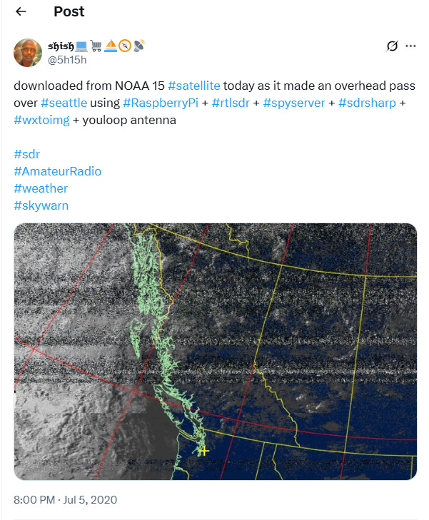
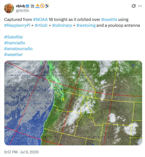
For example, I’ve received imagery from NOAA 15 and NOAA 18 satellites as they made passes over the Seattle area. The setup is relatively simple:
Hardware: Raspberry Pi + RTL-SDR dongle + YouLoop antenna
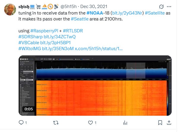
Software: SDRSharp (or SpyServer), WXtoIMG for decoding the signal, and optionally VB-Cable for audio routing
Process: Tune in to the satellite’s frequency (around 137 MHz for NOAA APT transmissions) at the scheduled pass time, capture the signal, and let WXtoIMG decode it into a full-color weather image.
Here are some captures from my recent passes:
NOAA 15 overhead pass producing crisp cloud cover imagery over the Pacific Northwest
NOAA 18 evening pass showing detailed weather systems along the U.S. West Coast
Live waterfall displays from SDRSharp during the signal reception window
𝔰𝔥𝔦𝔰𝔥💻🛒⛵🧭📡 on X: "tuning in to receive data from the #NOAA-18 (https://t.co/G9lgDtMw7U) #Satellite as it makes its pass over the #Seattle area at 2100hrs. using #RaspberryPi + #RTLSDR #SDRSharp https://t.co/4S9O4qLhAk #VBCable https://t.co/YZIJdwMOY3 #WXtoIMG https://t.co/HZr0t2tl1T https://t.co/wS9EVbDNst" / X
The result? Satellite photos beamed down directly to your own equipment, in real time, without relying on third-party weather sites. It’s a rewarding blend of space science, radio tech, and DIY hacking — perfect for anyone interested in satellites, ham radio, or weather tracking.


